Showing posts with label map. Show all posts

Monday, October 16, 2023

In Which Google Tries to Strand Me in Minnesota

Bike trail in Minnesota
Oct. 11--Morning on trail near Stillwater, Minnesota. Pretty, sunny fall day, I am on a bike ride with my wife.

Fall break at the university where I teach—three days off classes—has come and gone, and I’m back. No thanks to those high-tech wizards at Google.

My wife and I visited our oldest daughter and her family in Minnesota over break. We took bicycles and a Tag-a-Long seat that hitches to my hybrid bike, Clarence.

On Wednesday, it rained in Iowa, but we weren’t in Iowa. We were hundreds of miles north near the Twin Cities in a town called Mahtomedi. And on this day, we drove a short distance from our daughter’s house in that suburb of Saint Paul to Stillwater, on the St. Croix River between Minnesota and Wisconsin. We took out our bikes in our minvan and enjoyed a 10-mile ride along the river and into the countryside.

We then put our bikes back in the van and walked downtown for a nice lunch.

Wednesday morning ride.

Later, after my grandson got out of kindergarten for the day, I attached the Tag-A-Long and we headed out.

And got lost. We had found a trail, rode along it for a while, but on the way back didn’t recognize the turnoff. We both noticed it about the same time.

“I don’t think we were here before,” the child said.

Grandpa agreed. And didn’t have the address of his daughter’s house. But that’s why cell phones were invented, a quick phone call and text later, and the address was put into Google maps.

And then I had to try to follow the Google map directions home. I don’t have a way to hold the phone in view while biking, so I had to depend on its feminine robot voice directing me, which was, frankly, a true pain.

I can’t say I don’t like Google maps. The systems works far better than the first generation of GPS devices, and we use Google all the time when driving—it’s how we found our daughter’s house on Tuesday.

But have you ever tried to bike with Google maps? It sort of works in that it will show you a route, but the timing is all wrong. In the car, we had a navigator to watch the map while the driver drove, which helped, but the voice gives usually timely instructions on which fork or exit to take.

Usually. Google’s directions aren’t 100 percent, but they’re pretty good.

For driving. Not so much for biking. The robot voice doesn’t seem to grasp when to tell you something on a bike. Distances and speeds are all different, and it feels like the voice tells me things I don’t need too far in advance.

Anyway, the Google voice didn’t help much. But by pausing and checking the map now and then, I was able to suss it out. Eventually, I recognized the name of the street that leads to the street my daughter lives on, and we were on our way home.

Fortunately, my 5-year-old grandson loves biking and didn’t mind the extra distance. As we drew near the end of the ride, he informed me that, however, he didn’t want to stop at a neighborhood park we had planned to play at anymore; he wanted to go straight home.

Until we got right by the park and he could see it. His tune changed, which was fine by me, it was a cool but pretty, sunny fall day and if he wanted to play at a park for a while, well, why not?

He unexpectedly met a girl in his class there and they enjoyed running around, playing quick games on the equipment. At some point, he wanted to use my camera to try to take a picture, and I let him. (It was a portrait of me that I did not save since it was just my blurry forehead with some trees in the background).

Grandfather and grandson by bike
My grandson and I ready for our afternoon bike ride adventure.

After 30 minutes or so, he was ready to head home and his classmate was ready to leave, too, so we said our goodbyes, she to go with her mom to pick up a sibling from dance class, my grandson and I to ride to his house.

It added up to a 5-mile ride, which I enjoyed, aside from being briefly misplaced.

The next day, Thursday, was cloudy and windy and cool. It was supposed to rain that afternoon, but I headed out on a morning bike ride. There is a trail that leads from my daughter’s suburb to Saint Paul, and my goal was to ride in that direction. I had no intention of going into the city, I just wanted to ride on a prominent trail I hadn’t been on before.

And Google’s directions, in this case, were an epic fail.

I had put in what seemed like the nearest trailhead on my chosen route and informed my phone that I planned to bicycle there. And I was off. At first, the directions took me along streets that weren’t bad, more or less in the direction that I thought I should go, although to be fair, my sense of direction is useless in the spaghetti of streets in this suburb.

I rode by a park and through a four-way stop. The robot voice directed me that, in 1,000 feet, I would turn right.

However, the block that I was riding on ended in a dead end. There was no street off to my right. I rode back to the park, and decided to try again. I ended my ride and picked a different trailhead along my target trail. The robot voice told me to go to the street and turn right. Which I did.

And then it took me down the same dead-end block. On my way back out of the block, it told me to turn right onto a street that wasn’t there. However, there was a gravel trail off to my right, so I figured, why not?

At least I could turn, even if the imaginary street wasn’t there.

Biker lost in park
Selfie of a lost biker.

I was clearly in a large park, crisscrossed by limestone trails. I found myself wishing that I was riding my mountain bike, The Fancy Beast, but at least I wasn’t on Argent, my road bike. The hybrid’s slightly wider tyres weren’t the best on these trails, buts still better than skinny road bike tyres.

Near a pretty pond, I paused and took a selfie with my phone and posted it to Instagram and Facebook and a family group on Whats App. “Where is Joe?” I asked. Seriously, where was he? He didn’t really know.

My son-in-law helpfully replied that I was in Minnesota. Thanks, man. I think I was in Katherine Abbott Park, although, to be honest, that's a guess.

Bike in a park
My bike in a park in Minnesota Oct. 12. Based on later research, probably Katherine Abbott Park in Mahtomedi. Maybe.
Bike on trail
Another view of bike on trail somewhere in Minnesota. I didn't mind, it was a pretty ride, but I would have preferred a bit of clarity on where I was.
Bike, trail and downed tree limb.
Up ahead, a downed tree limb. Even on the hybrid bike, it wasn't hard to go around, and most of the trails were clear, even if I had to take it easy on this bike. Mountain Bike would have been better for this part of the ride.
Sign near school.
Sign near school in Mahtomedi. From bike trail, the "or" was too small to see, so to me, the sign said "No hunting trespassing." Since this school area was marked that way, I assume hunting trespassing is allowed in most of the state.
Bike near school
I made it to school and am ready to turn back. From here, I can find my own way, which is good news considering my recent experience with electronic navigation.

I made my way through the park to a street on the other side. Eventually, by accident, I made my way to the bike trail my grandson and I had been on the day before. By now, I had shut Google down, because Ms. Biker Robot Voice was being less than helpful.

I cycled through downtown, just enjoying the day despite the chill and grey. Eventually, I ended up outside of the elementary school where my daughter works, and took another selfie, just to show that the biker who was lost had again been found.

No thanks to Google.

Several years ago, when my small family team was riding on RAGBRAI and was seeking a host house in a strange town, my sister entered the address into Google maps and we were off. Way off. We ended up on an odd, roundabout route that involved, for one thing, an extensive detour along a gravel road. Google, way back then, was not all that reliable for biking. Ironically, the next morning, using directions from our human hosts, we had a relatively easy paved ride back to the big ride.

Milkweed seeds
What's a lost biker to do in a park? Take plant pictures, clearly. Milkweed seeds above, fall colors below.

Fall leaves

Maybe it should be a sense of comfort, in this era of rapid change, that some things seem to remain the same. For biking, at least for me, Google is a very poor tool.

Well, to be fair, I do like it for driving. And my idea on Thursday was to ride with no particular goal in mind, and if I got lost and ended up getting some extra miles but still made it to my daughter’s house in time to make cinnamon rolls to go with the chili my wife was creating in a crock pot for dinner—well, no harm done.

Maps of the longest of the Minnesota rides:

The crazy Thursday ride.

The two days of bike rides was followed by an all-day cold rain. Saturday, we went a local pumpkin festival, and then my wife and I drove home.

Using Google Maps. Which, as usual, was fine. For driving.

Sunday, I took a quick ride along some local trails. It was again cool and sunny, a pretty fall day in Iowa. I love cools days for rides. And while I like bike adventures, it was nice to be in a place where the internet wouldn’t try to strand me in the wilderness.

As of Oct. 16, 114.71 miles for the month and 2,852 for the year. And thanks, Google, for arranging a few extra of those miles. Images from pretty Sunday ride:


Friday, June 21, 2019

In Which I Get Lost and Found

Me, with son-in-law's bike, ready for first ride.
Wednesday, June 19—my son-in-law is off on a business trip and gave me permission to borrow his bicycle.

Today is the first ride. I grab my new helmet and his bike. The immediate problem is that he has odd pedals—specialized toe clips that I assume fit some shoes he wears to ride. Comparatively, I have large, fat feet. Getting those big feet into his clips in my wider shoes proves challenging. Alternatively, I could ride with my feet on the uncomfortable back side of his pedals, but I worry I may be damaging his clip straps by scraping them on the ground, and the back side is clearly not intended for use. Or, I can sort of mash down his clips with my big feet—but again, I don’t want to cause any damage to these clips.

I compromise—use the back side in busy situations where I don’t have time to mess with the clips, but ride in the clips on a trail when I have more time. (On my second, Thursday ride, I was more used to the clips and it was far less of an issue).

But my main issue on this ride was to find Mariott’s Way (spelled with an apostrophe on a sign on the trail, without on the trail map, so I don’t know which is correct but then again, neither do the British), a large bicycle path that slices through Norwich from northeast to southwest and continues for miles in the countryside in either direction.

It is not far from my daughter-in-law’s house. But navigating English streets is a challenge.

There is the obvious problem of remembering to ride on the “opposite” side. I did have to constantly remind myself of that, although I didn’t ever forget. Of course, my instincts of how to watch for traffic were all backwards. However, that made less difference than I thought—by-streets are so narrow that traffic basically moves down the middle anyway, so the difference between the American right side and British left side was only theoretical.

Narrow British street (above) and narrow walkway behind house (below).


Anyway, I had my map and I was off. Very off. Getting lost proved quite easy.

Not too lost, mind you. The issue was finding Mariott’s Way—I never had the sense that I would be unable to get back to the house. I was trying to be careful to minimize turns and to recall landmarks whenever I did make a turn.

The problem was reading and interpreting the map. Now, I am old. That means I grew up long before Google, and map reading was a skill taught in my elementary school days. But interpreting a map in Norwich was different. For one thing, as an old Roman town, the city is arranged with a center from which roads spread out like the spokes of a bicycle wheel—there literally is no street grid. Finding a route that follows a compass direction is not the same as it is in the U.S. where most towns have rectangular grids of roads.

And the British are cute and coy with signage. On the main “spokes” from city center, street signs are rare. Their attitude seems to be that if you’re on a main road, you ought to know where you are, so there is no need of intersection street signs. Side streets are sometimes marked—now always—but the location and appearance of the signs are not in any way standard.

Is “Bobs Your Uncle” the name of a pub or the name of the alley-wide road? Well, if it’s also on the map, it’s a road—and the street signs, various as a they are, are lower and smaller than the signs for commercial establishments.

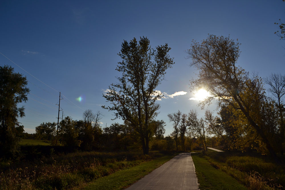
All in all, the first ride was mostly spent in going back and forth and failing to find the main, most obvious bike path in all of Norwich.

After some back-and-forth, complicated by the idea that I would never be able to repeat the route since I could not figure out how I got there in the first place, I found what seemed to be Mariott’s Way. Or at least I think I did. Hard to say. Mariott’s Way, in Norwich, is apparently a “main” bike road, which means there isn’t any reason for a sign to identify it, because you wouldn’t use it if you didn’t mean to, right?

Some scenes along the trail Wednesday. On Thursday, I could confirm that it was indeed the trail I was looking for.


I may sound like I’m whining. I suppose I am. I miss wide American streets, but mostly I miss rectangular street grids. Beyond that, I truly appreciate the American penchant for uniform and almost universal street corner signage. I suppose one reason the Brits don’t do this is because their walkways and streets are so narrow that such signs would take up valuable space at corners, but trust me English cousins, it’s totally worth it.

But despite the whine, it was a cool and pretty afternoon—cloudy but nice, and I did enjoy being out and moving on the bicycle. I rode a mile or so down the bike trail, presuming it was the one I wanted, and vowed to return the next day (by more direct route) for a longer ride.

Thursday, June 20—We have minor travel plans today. After dropping the kids off at school, we head over to the Coop to get a sim card for my wife’s phone. In preparation for today’s ride, on Wednesday night my daughter and I installed a new card in my phone—and wonder of wonders, I have now a fully functioning mobile phone in the UK!

The attempt to do the same for my wife ended in frustration, for now. Anyway, after the morning shopping, my daughter drove us to a bookshop somewhere in the Norfolk countryside. It was an interesting place—a shop that appeared to be located in someone’s country home, with a longish room stuffed with a dizzying array of children’s books. Our luggage for the return flight home may be a bit heavier.

We stopped at a tea room at a nearby sort of shopping mall for arts and crafts. By the time we got home, it was time to think of the afternoon school run—which I didn’t go on. Bicycle time!

Walkway along a river, somewhere in Norwich. I feel I should not be riding Matt's bike here, but then again I got innocently lost.

 Everything was a bit easier, this time. I had a plan to manage the toe clips. (Matthew, they were frozen by rust in your settings, but rust will respond to vigorous force—check the clips before you ride again, they have been made looser to fit much larger feet).

I got to the trail and cycled north. It was a sunnier day, some broken clouds, but some blue sky, too. I brought my sunglasses, but hadn’t worn then on the half-mile trek to the trail, partly because I wanted the best vision possible to the spot the subtle bread crumbs of signs left by the British. The trail was so shady that I ended up sans shades for the whole ride.

I rode as far as the village of Darby, probably a 4-mile journey. Half of that was on dirt, and recent rains had made parts of that ride a bit muddy, so I decided to stick to paved, urban trail in Norwich proper. I headed towards city center next, and somewhere near a river I lost the trail. I had a short ride along the river, which was pretty, and I apologize to all the fishers whose walkway I inadvertently intruded upon, but then again, Brits, if you don’t want wandering Americans lost on your sidewalks, you might consider more obvious signs.

I rode back and forth on several miles of paved trail in town. Next week, when I will be riding a rented bike, I intend to go farther, paying more attention to the trail and hopefully making it through Norwich to explore in the southern direction—but did not today partly because I wanted to avoid City Center in rush hour. Still, the Thursday ride was nice.

Map My Ride functions again, and in an hour and 50 minutes I rode 18 miles. I hope to top 50 on at least one day next week, but for now I feel a sense of success. I have found the trail! Way out in Darby I even found a sign that confirmed it as Marriott’s Way!

Hooray for signs!


A sign! And below, seen from the trail Thursday, a horse!